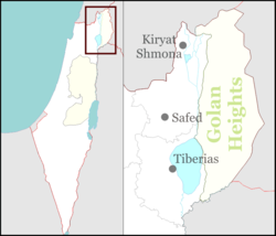
Safed is an Arab city, and the district base bears its name. It is the capital of the Upper Galilee, and the most important site in it, and it has been under Israeli occupation since 1948 until now.
A- The natural framework of Safed:
1) Geographical location: The site of Safed has occupied an important position throughout historical times, and it continues to do so. Its fortified citadel was of great importance during the decline of the Franks, because of its supervision over the northern part of the Galilee region, and on the road between Damascus and Acre*, and the military invasions were keen to occupy Safed, in preparation for controlling the Galilee.
Its commercial location was no less important than its strategic location, as Safed was a postal station* between the Levant and Egypt during the Mamluk era*. Mail comes to it via Gaza*, Lydda*, Jenin* and Hattin, and from there to Damascus via the Banat Yaqoub Bridge* on the Jordan River*. Homing pigeons also used to come to it from Egypt, following the same route. In the Roman and Islamic eras, it was a stop on the trade caravan route between the Levant and Egypt.
The ruling authorities chose the city of Safed as the administrative center for the Upper Galilee region, due to its important geographical location in the Mediterranean. During the era of the British Mandate, Safed was the headquarters of the administration of the region, and a gathering point for the transportation routes that connected it to the Galilee region and the neighboring regions of Palestine, Syria, and Lebanon (see: administration). In addition to the main roads, there are secondary roads linking Safed to its neighboring Arab villages. It is 29 km from the northern border of Palestine, 40 km from Al-Khalisa, 36 km from Tarshiha, 48 km from the station, 74 km from Haifa, 165 km from Lod, 175 km from Jaffa, 206 km from Jerusalem, and Beersheba* 264 km.
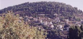
2) The land of Safed: Safed is located on a mountainous area whose height ranges between 790 and 840 meters above sea level. It is surrounded to the northwest by Mount Safad, which ranges between 600 and 820 metres. Also extending to the north and northeast of the city is Mount Canaan, whose height exceeds 950 metres. To the southeast of Safed extends the mountainous Al-Dhahiria Al-Fawqa area. Which falls with a steep edge on the middle Jordan Valley, while the mountains of Zuyud and Al-Jarmaq stand tall west of Safed. Its peaks represent the highest mountain peaks in Palestine (1,100 – 1,200 m).
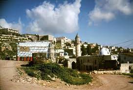
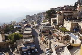
Safed was built on several hills separated by valleys heading south. And the northwestern hill. Which is a southern extension of the foot of Mount Canaan, it is the oldest inhabited spot in Safed. There is no doubt that the protection factor was the main motivation for the emergence of ancient Safed. The city then extended towards the south, surrounding its castle, which was built by the Arabs. A fortified wall and a wide moat were built around Safed to protect it from the dangers of aggressors. However, the city expanded its development beyond the wall as a result of the increase in its population and expansion, to the point that buildings occupied the valleys, just as they occupied the hills and slopes.
The city of Safed is surrounded from the north by one of the tributaries of Wadi al-Laymun, which supplies Wadi Amud*, which ends in Lake Tiberias*, and some of the valleys tributary to Wadi Amud begin. From the mountains extending at the southern end of Safed. These valleys have formed gorges in the mountain highlands that originally consisted of limestone rocks. The Safed region is exposed to earthquakes and earthquakes* as a result of the instability of the earth’s crust with its modern geological formations, and the presence of reliable faults (fractures), some of which were the location of the paths of valley streams. One of the most famous earthquakes to which Safed was exposed was the earthquake of 1837, which killed many of the city’s residents.
3) Climate* and water: Safed’s climate belongs to the Mediterranean climate. The altitude factor affects the city’s climate, as the mountainous nature of the city was reflected in its climate, making it pleasant in the summer and cold in the winter. Thus, Safed is one of the beautiful resorts of Palestine, where forests cover areas of its mountains. The region gains a beauty similar to the beauty of the Ramallah region*. The average temperature in August ranges from a low of 18 to a high of 29, while the average temperature in January ranges from a low of 4 to a high of 10.
Rainfall in large quantities falls on the city of Safed. The average annual amount of rain is about 728 mm, which is a large amount when compared to the amounts received by other cities of Palestine. Snow falls in Safed almost every year. Like rain, it contributes to feeding groundwater reservoirs after it melts.
Water is available in the Safed area. Especially spring water, which is used for drinking and irrigation purposes. Springs abound in depressions, valley bottoms, along the feet of mountains, and faults (fractures). Among the famous springs are Ain al-Afiya, Ain al-Hasil, Ain al-Zarqa, Ain al-Jinn, and Ain al-Tabneh (see: water springs). Water comes to Safed from two springs that emerge east of Safed, and they are called Ain al-Rummanah and Ain al-Labiwiyya. As for wells*, their number ranges between 20 and 30, and they cost a lot to dig due to the depth of their groundwater reservoirs. Agriculture* depends on sufficient rainwater for the growth of all types of crops.
B- Origins and growth: The city of Safed was founded. Like many other cities of Palestine in early historical times, it was destroyed by the Canaanites. Its old name is “Safat”, which means giving or bonding. When it was founded, it was a small village of insignificant importance, and it remained that way for long periods of time. It was occupied by the Romans and it was a fortified castle during their reign. It did not have a great importance in early Islam, and it was not mentioned in the first Arab conquests, and the oldest mention of it dates back to the tenth century AD.
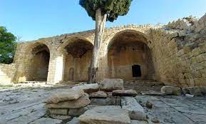
The city of Safed clearly emerged among the events of the Crusades, as the Crusaders occupied it in the year 536 AH/1140 AD and built a fortress there to defend the coast they had conquered from attacks by the princes of Damascus and the Ayyubids (see: the Franks). In the year 553 AH / 1157 AD, Khudwin III, king of the Crusaders, took refuge in this fort after his army was defeated in front of the soldiers of the just King Nur al-Din Mahmoud bin Zengi * at the site of navigation * When Saladin Al-Ayyubi * was victorious in the Battle of Hattin * in the year 583 AH / 1187 AD, he besieged the city of Safed, and he took over the city. He took control of the fighting, and succeeded in seizing the city and the fort in the year 586 AH/1189 AD. In the year 618 AH/1220 AD, the Muslims destroyed the fort for fear that the Crusaders would seize it again. In the year 639 AH/1240 AD, Safad returned to the rule of the Crusaders, and they built the fort there again and it remained in their hands until Sultan al-Zahir Baybars captured the fort, seized it, and recovered it from the Crusaders in the year 667 AH/1267 AD. King Baybars* built a mosque in the fort, and renovated the buildings of the city of Safed and flooded it after it was liberated from the control of the invaders. During the Mamluk era, Safad remained an important center, and it became the story of one of the Syrian governorates that included all the cities of Galilee and the city of Acre as well. After this date, the city of Safed gradually lost its importance until it surrendered, along with the other cities of Palestine, to the Ottomans during the time of Sultan Selim without war in the year 923 AH/1517 AD, and became the Kasbah of Sanjak, followed by the cities of Galilee, the city of Akka, and Tire (see: administration). In the seventeenth century, Prince Fakhr al-Din ibn Qarqmaz* al-Ma’ni II occupied an important position in Galilee. He took Safed as a fortress to protect his properties there. But the Turks eliminated him, and after that an emirate was established for the Shihabis, and the Shihabis appointed Omar bin Zaidan as sheikh of Safad to help them. Sheikh Omar’s influence expanded over time, and in the year 1164 AH/1750 AD, his son, Sheikh Zahir al-Omar*, became independent of the Shihabis and took the city of Acre as his headquarters. During the reign of Sheikh Zahir, agriculture, trade, and architecture became active. People felt safe. In the year 1173 AH/1759 AD, the city of Safed was hit by an earthquake that nearly destroyed its residents and buildings. In the year 1182 AH/1768 AD, Sheikh Zahir al-Omar became Emir of Galilee. He ruled Safed, Acre, and Nazareth, and tried to gain independence from the Ottoman Empire. But he was assassinated. After him, the Turkish governor Ahmed Pasha al-Jazzar* ruled Safad. Before Napoleon besieged Acre, he had to occupy Safed first in the year 1214 AH/1799 AD. But he met with violent resistance from the governor, Ahmed Pasha Al-Jazzar, with the help of the English fleet. He failed to achieve his goals in his military campaign, and his forces withdrew from the Levant and Palestine (see: the French campaign).
In the early seventeenth century, Safad was a prosperous city. The Swiss traveler Burckhardt saw it while passing through it in the year 1227 AH/1812. He found it to be a spring town located around a hill with a castle at the top, surrounded by a wall and a moat, surrounded by olive and vineyards, and its people working in making indigo and weaving fabrics. Al-Qatniya, where a market was held for neighboring villagers every Friday. In the year 1235 AH/1819 AD, it was struck by another earthquake, causing severe damage. In the year 1248 AH/1833 AD, it was occupied by Ibrahim Pasha, the son of the governor of Egypt. In the year 1253 AH/1837 AD, it was hit by a third earthquake, after which the city turned into a small village due to the comprehensive destruction it was exposed to. In the year 1257 AH/1841 AD, it returned to Ottoman rule, and in the year 1304 AH/1886 AD, Safad became a judicial center in the Sanjak of Akka. At this time, it witnessed some urban progress. In 1918 AD, it was occupied by the British during World War I.
During the era of the British Mandate, the district of Safad included more than sixty Arab villages, the most important of which were Abel al-Qamh*, Beriya*, al-Buwayziyah*, al-Khalisa, al-Ja’una*, al-Zuq al-Tahtani*, al-Rayhaniyah*, Sa`sa*, al-Shouna*, al-Salihiyya*, al-Safsaf*, al-Azizat*, Akbara, Alma*, Ain al-Zaytoun*, Quds*, Qadita*, and al-Malha* Al-Mansoura, Al-Naameh, Hunin, Toba Al-Shamaliah, Kafr Bir’im, Jahoula, Al-Badwara, Tabtia, Khyam Al-Walid, Al-Zangriya, and others. These were Arab clans residing in these villages or in their vicinity, the most important of which were the Ghawarna Arabs who settled in Al-Khalisa and its neighboring villages, the Al-Hib Arabs, the Northern Arabs, the Kaoush Arabs, the Muhammadat Arabs, and the Sayyada Arabs.
The total population of Safed in 1908 was about 10,000 people. During World War I, it included 4,000 homes and 12,000 people. The city included multiple neighborhoods, three of which extended at the foot of Mount Canaan. Among its neighborhoods are the Kurds, Al-Diyana, Al-Joura, Al-Qalaa, Al-Burj, Al-Sawawin, Al-Ahmar Mosque, Al-Wata, and Al-Souq. The best-developed neighborhood is the Qalaa neighborhood, which includes about 100 modern homes. With the exception of approximately 400 modern-style brick-roofed houses, the rest of Safed’s houses are built in the old style, with white stones, close together. Most of the houses in Safed consist of one floor. The new buildings have given the city of Safed a remarkable architectural beauty.
The city center of Safed includes markets that include 80 shops. It contains mosques, the most important of which are Al-Yunsi Mosque, Al-Ahmar Mosque, Al-Suwaiqa Mosque, Al-Juqandari Mosque, Sayyidna Yaqoub Mosque, and Khafaja Mosque (see: mosques and mosques). Also located in the city center are the government house, the hospital, and some government offices. The plan of Safed takes a circular or semi-circular shape. Meaning that the streets surround the heart of the city in circular shapes, so the city center represents the focus into which the city streets flow from the edges. There is no doubt that the mountainous nature of the land of Safed imposed on the plan such a circular, radial shape.
During the British Mandate, Safed retained its general appearance. Despite the development of its population and urban growth. In 1922, the city’s population reached 8,761 people. This is the lowest it was before and during World War I. The decline in population is due to the bad conditions that the city experienced during the war, as many of its residents were exposed to diseases and famine. Some of them migrated abroad seeking ample livelihood. After the situation stabilized a little in the city, its size began to gradually increase, and its population rose in 1931 to 9,441 people, who lived in 2,126 homes. In 1945, the population reached 11,930 people, and their number at the end of the Mandate was estimated at 13,386 people.
The urban expansion of Safad expanded, reaching an area of 1,429 dunums in 1945. The Municipality of Safed supervised the city’s affairs and its engineering organization. Municipal expenses have doubled from 2,196 EGP 1927 to 5.102 EGP. In 1944. The municipality issued 98 building permits in 1935, and 113 building permits in 1944. It contributed to the implementation of vital projects, such as water, electricity, streets, schools, and others. The impact of its activity was evident in the establishment of markets, hotels, cafes, clubs and parks.
The Arab population was concentrated in the eastern and southern parts of the city, and the Jews were concentrated in the western part of it. The Arabs strove to liberate their city from Zionist settlers throughout the Mandate period, and their jihad reached its peak in the 1948 war*. But the Zionists were able to control the situation and occupy Safed on 5/12/1948 (see: Safed, battle). The war resulted in the deportation of most of the Arab population from Safed, and its population decreased to 2,317 people in late 1948. The population soon increased with the arrival of Zionist settlers to it steadily, reaching 4,000 Zionists in late 1949, and 5,500 in late 1950. Then their number jumped to 15,900 in 1983. A new residential suburb was built east of Safed, while in 2001 the population reached 25,000 thousand people.
C- The functional structure of Safed: Since its first establishment, Safed contributed to a few functions, such as military, commercial, and agricultural functions. Then the city developed over time, as its size grew, its area expanded, and its functions diversified.
1) Military function: Safed has exercised its military function since its inception, by virtue of its topographical situation, which facilitates the task of defense and protection from the dangers of aggressors. Due to its geographical location, it overlooks the neighboring areas and overlooks natural outlets. It controls the roads leading to those areas. It overlooks the Hula Plain* in the north, and Lake Tiberias in the south-east, and from the west it controls the Akka-Ramah-Fardiya road, and it controls the roads leading to the northern borders of Palestine. For this reason, Israel was keen to occupy it at the beginning of the 1948 war, so that it could control the entire Galilee.
3) Administrative function: The city was the center of the Safad District in the Ottoman and British eras. From 1899 until the end of the Ottoman era, the Safad District included 78 farms and villages. During the British era, the aforementioned district included the city of Safed and 69 villages. In addition to several Arab clans that lived near some villages. At the end of the Ottoman era, the area of Safad district reached 750 km2, and in 1945 its area became about 696 km2.
The population of Safed in 1904 AD was about 22,715 people. Their number increased in 1908 and reached 26,113. In the late Ottoman era, their number increased to 32,137. In 1922, the population of Safed District decreased to 22,790 people. Then it rose to 39,713 people in 1931. In 1945, their number was estimated at about 53,620 people. The population density was 77 people per square kilometre.
The administration of the government in Safed during the Mandate was supervised by an Arab mayor subordinate to the governor of the district in Nazareth*. The city included courts and government departments for agriculture, health, post, and lands. As for the schools, they were affiliated with the Education Inspector in Haifa. Public security was supervised by the Palestinian police, headed by a British inspector. The residents of the district benefited from the administrative services provided to them by Safed throughout the period of the British Mandate. But the situation changed after 1948, as Safed became a district center in the Northern Province, stemming from a group of Jewish colonies, most of which were established on the lands of destroyed Arab villages.
3) Agricultural function: The mountainous lands surrounding Safed are suitable for growing cotton, grapes, olives, and tobacco. The city is surrounded by orchards of fruit trees such as grapes and olives on the slopes of the mountains. As for grains, vegetables, and some types of fruits, they are spread in the valleys and valleys. Sweet lemon cultivation is widespread in Wadi al-Laymoun, located on the western slopes of the city, and is also known as Wadi al-Tawaheen.
Extending to the southeast of Safed is Wadi al-Hamra, which is filled with orchards and supplies the city with half of its needs for fruits and vegetables. Especially berries, cherries, pomegranates and tomatoes. Safad derived the rest of the agricultural products it needed from the neighboring Arab villages. The most important agricultural crops produced by the Safad district are olives, grapes, figs, watermelon, apricots, plums, peaches, kashmari, oranges, wheat, barley, corn, and various types of vegetables.
4) Commercial function: Safed was a stop for the passage of commercial qawafi in the past, a marketing center for its region’s agricultural and animal products, and a commercial center where villagers found what they required of food supplies, fabrics, clothing, electrical and household tools…etc. Safed’s markets were full of agricultural, animal, and forest products. Such as tomatoes, grapes, figs, lemons, wheat, various types of legumes, dairy products, charcoal, firewood, etc. In addition to these markets, a main market was held every Friday. Many residents of the region visit it to exchange various products.
What encouraged the commercial movement in Safed is that it is a tourist center and a famous resort in Palestine, as it resembles touristic elements, such as beautiful natural landscapes such as tall trees and springs of water*. And archaeological and historical places. Therefore, there are many hotels and shops that promote commercial activity. Various means of transportation (see: tourism) are active.
Most of the Arab residents of Safed were engaged in trade and were professionals in selling. Before Israel occupied the city in 1948.
5) Industrial function: Safed has known some industries since ancient times, as the felt industry arose there, relying on the wool provided by the sheep of the region. During the nineteenth century, indigo dyeing and weaving of cotton fabrics were the main occupations of the people of Safed. During the era of the British Mandate, new industries were added to the previous industries, such as food industries (r: food, industry), wood and leather industries, the manufacture of vegetables and chairs from the plants of the Hula Plain, and other traditional light industries.
Industry* developed in Safed after 1948, when the Zionist occupiers turned it into an industrial city to establish the feet of the new generation there. Despite this, the new generation of Jews was born in Safed (Sabra). They refrained from living in the city, and began to leave it. One of Safed’s most important industries is the food industry, such as sweets, chocolate, mousse (unbreaded Jewish bread), coffee, and others. There are industries such as smokehouses, sewing machines, stoves, bicycles, diamond cutting (see: diamond, industry), textiles, clothing, printing, and building materials. Tourism is at the top of the city’s industries, especially in Mount Canaan, a thriving resort.
6) Educational function: The Rashidiya School was established in Safed in 1880 AD. In the late nineteenth century, it included 30 students. The English had a preparatory school that included 50 students at the same time. During World War I, the number of schools in the center of the district and in all its annexes reached ten official schools and 26 unofficial schools, including three schools for boys and one school for girls in Safed. These schools included 280 male and 150 female students.
Education developed in Safed during the British Mandate. In the academic year 1942/1943, Safed included three boys’ schools (two primary schools and a secondary school) and a girls’ school. All of these schools included 805 students, taught by 24 teachers, and 319 girls taught by 11 teachers. In the academic year 1946/1947, there were three schools for boys and two schools for girls in Safed, and the total number of students in these five schools in October 1947 was approximately two thousand. Safed was famous for its Scottish College, which taught English and mathematics, but after World War II it moved to the city of Haifa (see: Education).
The impact of the progress of education on the rise in the cultural, social and economic levels of the population of Safed. The educated people of the city contributed positively to the upbringing and education of the people of other Palestinian cities and villages. They also contributed to spreading culture and awareness among the people of Safed, which had a positive impact on their struggle against British and Zionist colonialism in Palestine.
the reviewer:
– Mohsen Al-Amin: Plans for Jabal Amel, Beirut 1961.
– Abd al-Hayy ibn al-Imad al-Hanbali: Nuggets of Gold in Akhbar Min Dahab, vol. 3, Cairo 1931.
– Al-Qalqashandi: Subh al-A’sha, vol. 4, Cairo 1914.
– Philip Hitti: Lebanon in History (translated), Beirut 1959.
– Mustafa Murad Al-Dabbagh: Our Country is Palestine, vol. 6, vol. 2, Beirut 1974.
– Ibn Shaddad: Dangerous Relationships in Mentioning the Emirs of the Levant and the Peninsula, Damascus 1953.
– Mahmoud Al-Abidi: Safed in History, Amman 1977.
– Smith, G.A.: The Historical Geography of the Holy Land. London 1996.
– The World Gazettzer, Current Population for Cities and Tours of Israel (Internet).